Thursday, January 20, 2011

To build or not to build a dam –that is the question

The proposed Traveston dam on the Mary River was always considered controversial. When the Rudd Government environment minister, Peter Garrett blocked the building of the dam, the people in the region were quite happy. The Queensland Premier, Anna Bligh did not attempt to protest the blocking of the dam but instead she decided to take the route of building a desalinisation plant.  The question to be asked right now, though, is whether or not the blocking of the dam, in light of the floods experienced last year and again this year, made matters worse for the flooding of Brisbane.

First of all,  here is a little bit of perspective regarding the region under discussion and how it relates to Brisbane:
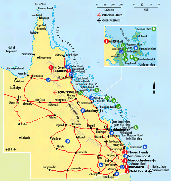


As you can see from the map, Maryborough is to the north of Brisbane, and below Rockhampton, Hervey Bay and Bundaberg. Toowoomba is to the west of Brisbane.

During December the Fitzroy river, which flows through Rockhampton was in flood, and it was the same in early January.  From this map we should be able to trace the flow of the waters from the Fitzroy River, and into the Wivenhoe dam.  The rains in this region had been heavy since at least September 2010, which in effect explains why the Wivenhoe dam had reached capacity.

Now let us look at the reasons that Garrett rejected the building of a dam on the Mary River. Keep in mind that the residents were against the building of the dam (which is natural since they would have been displaced). However, the reason for the decision was based upon the fact that three endangered species that rely upon the Mary River would have been displaced. These species are: the Australian lung fish, the Mary River turtle, and the Mary River cod. The building of the dam would have destroyed the natural habitat of these species.  However, Garrett did not base his decision to ban the dam on the impact of these species, but he based it upon a report from the Centre for International Economics which came to the conclusion that the decision by the Queensland Government to go ahead and build the dam was based upon flawed data.

If the project had been given the go ahead, then the dam would have been able to supply 70,000 megalitres of water to the Brisbane population.  It might or might not helped in the mitigation of the flood damage that was experienced in the towns south of Maryborough.

Since this was a recent project, there is doubt that had the dam being given approval to go ahead that it would have been finished in time, or at least prior to the rains brought by the La Nina.  The point is that even if the building of this dam was blocked, the Queensland government then did nothing to seek out alternative spots to build a dam, and instead chose to go ahead and build 4 desalination plants that have now been mothballed.

On top of that, I suspect that decisions were being made based upon the belief that “climate change” meant that Queensland would never see again the floods of the past. The Wivenhoe dam was built after the floods of 1974, and it was supposed to stop a similar kind of devastating flood from happening again.  There are plenty of questions to be asked about how the operators of the Wivenhoe dam were releasing water in the week prior to the devastating floods.  It is not so much the banning of the Traveston dam on the Mary River that helped to cause the situation, but the operation of the Wivenhoe that needs to be examined in some detail. Also, what needs to be questioned is why did the Queensland government fail to seek other alternative sites for a dam, sites that would have been more viable than the proposed Traveston, and sites that did not involve damaging the habitat of endangered species.

Tuesday, January 18, 2011

Brisbane floods–could this flood have been mitigated?

There are genuine questions to be asked about why the Wivenhoe Dam failed to protect Brisbane from its worst flood since 1974.  The history here is that the Wivenhoe Dam was built in response to the 1974 flood and it was supposed to protect Brisbane from this kind of disastrous flood. What went wrong?

Andrew Bolt has been asking some serious questions about why the operators of the Wivenhoe Dam failed to release larger amounts of water in the days preceding the heavy rains that led to the floods.  The issue raised by Bolt is that the Wivenhoe Dam at the time of the deluge was too full,  that it was in fact at about 160% capacity prior to the rains, and that the dam was filling up fast to the point where the flood gates would have opened automatically.

Bolt takes up the case presented by senior engineer Michael O’Brien who claims that the Brisbane flood was avoidable. The issue seems to centre around the fact that the SEQ water failed to release sufficient water from the dam in the week prior to the heavy rains, leading to the release of 645,00 mega litres on the morning of the Brisbane flood. This release was due to the rather alarming increase in the dam storage levels to about 190% capacity.

You can read the whole thing here.

Like Andrew Bolt I am not familiar with the information that has been provided. On the other hand, I have experienced a flood that was due to the opening of the Warragamba Dam’s floodgates. The effect of that action was quite significant, leading to serious flooding in the Richmond-Windsor district.  There is some similarity in circumstances because the flood was preceded by a week of heavy rain and then came the rising of the rivers which cut off the townships of Richmond and Windsor. In the case of Brisbane, as pointed out by Germaine Greer, the Wivenhoe had been as low as 10% capacity at one point, meaning that the SEQ operators of the dam might have been reluctant to release greater quantities of water.

At least Anna Bligh has ordered a Royal Commission into the floods, and hopefully the Royal Commission will examine all of the data that will explain why the Brisbane floods happened in the first place.

This is a different issue from the floods in Ipswich, Toowoomba and the Lockyer Valley.  The wall of water that came beating down on the residents of that region was also probably avoidable. 


Germaine Greer adds her two cents worth–Pt. 5 of a series

This is the second time that I have agreed with the gist of comments from Germaine Greer. This woman gets it!!  The first time that I agreed with Greer was about the causes of the devastating bush fires in Australia two years ago. In that instance Greer took the Greenies and the Globull warmists to task over their attempts to claim that the most devastating fire in Marysville and other areas in Victoria was due to Globull warming. On that occasion Greer made observations that I had also learned in the classroom.

This time Greer is refuting the attempts by Globull warmists to claim that the floods in Queensland have something to do with climate change (it does not).

Here is a part of what Greer had to say in her column:


What’s going on in Australia is rain… The ground is swollen with months of it. The new downpours have nowhere to go but sideways, across the vast floodplains of this ancient continent. We all learned the poem at school, about how ours is “a sunburnt country . . . of droughts and flooding rains"… And yet we still don’t get it. After 10 years of drought, we are having the inevitable flooding rains. The pattern is repeated regularly and yet Australians are still taken by surprise.

The meteorologists will tell you that the current deluge is a product of La Niña. At fairly regular intervals, atmospheric pressure on the western side of the Pacific falls; the trade winds blow from the cooler east side towards the trough, pushing warm surface water westwards towards the bordering land masses. As the water-laden air is driven over the land it cools and drops its load. In June last year the bureau of meteorology issued a warning that La Niña was about “to dump buckets” on Australia. In 1989-90 La Niña brought flooding to New South Wales and Victoria, in 1998 to New South Wales and Queensland… In Brisbane the benchmark was the flood of 1974; most Queenslanders are unaware that the worst flood in Brisbane’s history happened in 1893. Six months ago the meteorologists thought it was worthwhile to warn people to “get ready for a wet, late winter and a soaked spring and summer”. So what did the people do? Nothing. They said, “She’ll be right, mate”. She wasn’t.

It takes La Niña to bring rain to the inland, in such quantities that it can hardly be managed. Manage it Australians must. The Wivenhoe Dam on the Brisbane river was built to protect the city of Brisbane from another flood like the one of 1974. For years it has been at 10% of capacity [er, that’s a gross exaggeration, actually, but, yet, it was alarmingly low for a while], so when it filled this year nobody wanted to let any of the precious water out. It eventually became clear that the dam had filled to 190% of its capacity, and the authorities realised with sinking hearts not only that the floodgates would have to be opened [even wider, actually], but that the opening would coincide with a king tide in Moreton Bay. The question nobody [pardon?] has been heard to ask is whether or not the level of water in the dam should have been reduced gradually, beginning weeks ago…


Hat tip: Andrew Bolt


The poem that Greer mentions is “My Country” by Dorothea Mackellar. We all had to learn that poem by rote. We had to recite it perfectly when we were in school. Here is the full poem:

The love of field and coppice,
Of green and shaded lanes.
Of ordered woods and gardens
Is running in your veins,
Strong love of grey-blue distance
Brown streams and soft dim skies
I know but cannot share it,
My love is otherwise.


I love a sunburnt country,
A land of sweeping plains,
Of ragged mountain ranges,
Of droughts and flooding rains.
I love her far horizons,
I love her jewel-sea,
Her beauty and her terror -
The wide brown land for me!


A stark white ring-barked forest
All tragic to the moon,
The sapphire-misted mountains,
The hot gold hush of noon.
Green tangle of the brushes,
Where lithe lianas coil,
And orchids deck the tree-tops
And ferns the warm dark soil.


Core of my heart, my country!
Her pitiless blue sky,
When sick at heart, around us,
We see the cattle die -
But then the grey clouds gather,
And we can bless again
The drumming of an army,
The steady, soaking rain.


Core of my heart, my country!
Land of the Rainbow Gold,
For flood and fire and famine,
She pays us back threefold -
Over the thirsty paddocks,
Watch, after many days,
The filmy veil of greenness
That thickens as we gaze.


An opal-hearted country,
A wilful, lavish land -
All you who have not loved her,
You will not understand -
Though earth holds many splendours,
Wherever I may die,
I know to what brown country
My homing thoughts will fly.

I have changed the colour of the relevant stanzas of the poem because Dorothea Mackellar in her poem has encapsulated the truth about the Australian landscape. The droughts and the floods are a normal part of this country. This is why Governor Lachlan Macquarie designated the five Macquarie towns for settlements. He picked areas on high ground so that people would not be impacted by those floods.

Yet Australians today seem to not understand the very nature of the Australian weather patterns. This is yet another reason why these rains seem to have caught many people unawares. They should have been prepared, but they believed the big lie about Globull warming, and they believed the lie that the days of soaking rain were finished. They failed to understand the nature of La Nina.

The Macquarie Towns–Pt. 3 of a series

When I was first married I lived in the Richmond-Windsor district of NSW. These two towns were a part of the 5 towns designated by Governor Macquarie because they were on high ground. A summary of the life of Governor Lachlan Macquarie can be found here.

The Governor, his wife and a few others set about doing a survey along what is now known as the Hawkesbury River, which is a part of the Hawkesbury-Nepean river system. Macquarie designated Richmond, Windsor, Castlereagh, Pitt Town and Wilberforce for the purpose of settlements because they were on high ground and people would be safe from floods.

Now fast forward to the late 1900s where the NSW government began to release new land for sale in those same districts. The problem is that this land was in the flood plains, and was not a part of the designated area. When I lived in the area, I lived in Cox Street, at the top end near the railway line. The parallel street is George Street. The newly released land is at the other end of George Street. In the 1978 floods that land was under water.

I see this as a potential for a real disaster in the future. The Warragamba Dam which releases water that feeds into the Hawkesbury-Nepean river system, has not been at full capacity for a very long time. This is because a lot of the rainfall was not over the catchment area, yet we had flash floods in Sydney, and in some parts of the Castle Hill district we even had tornados from time to time. However, last year, in 2010, NSW had heavy rains, and this means that the Warragamba Dam is closer to full capacity.

If, as predicted, there is more rain in NSW and if that rain causes the Warragamba Dam to reach full capacity to the point where the flood gates are opened and the spill is released, then there is in my mind no doubt that there will be a big flood once again in the Richmond-Windsor district, and with a lot of new housing estates being flooded. This is because these housing estates have been built on the flood plains. The surveyors, and those responsible for town planning have ignored the possibility of floods in the area.

Whilst I cannot prove my statements, that there will be a big flood in that region, this brings me to looking at the situation of Queensland, where Brisbane has seen flooding at the same level as that of 1974, which was also quite devastating. Some of the issues that I have raised here about the designation of the Macquarie Towns also apply to regions in Queensland where the town planners have ignored the floods of the past, and in my view they have become sloppy because they believed the big Globull Warming lie.


Richmond-Windsor District flood March 1978–(pt. 2 of a series)

I grew up in Melbourne, and not once during my growing years did I ever encounter the devastation of a flood. This is despite the fact that Victoria had her share of floods during that same period. Places such as Echuca, Horsham and Shepparton were known to be flood prone. Even in my family tree, there is the death of a boy aged about 14 that was probably a drowning due to floods in Horsham (I need to verify that point).

However, things changed when I married and relocated to the Richmond-Windsor district. First of all, in 1977, when I was living in a unit in Richmond, there was a minor flood. This happened when I was away visiting my in-laws who were living at Port Macquarie at the time. Our top floor unit was flooded due to the debris on the roof. However, it was the following year that I ended up in the middle of a flood.

It was in March 1978 that we had a week of non-stop rains. I had a newborn son (my oldest) and we had arranged that he would be baptized at the Easter Vigil at our local church, St. Matthews, Windsor. Since my husband was in the RAAF at the time, we were expecting our relatives to arrive from both Melbourne and Newcastle in time for the Baptism. What happened though, is that the region became flooded because of the heavy rains.

My memory of the whole thing has faded over time, but I do remember that there had been several deaths. Two of those deaths were a couple whose vehicle had been washed away in Toongabbie. The one that I remember most, though, was in Windsor, where a teenage boy was electrocuted when his boat touched overhead electricity wires as he was attempting to rescue people. This accident happened somewhere near a tavern known as the Jolly Green Frog which is located close to McGrath’s Hill.

This flood occurred because Warragamba dam had been full to capacity due to the rains that NSW had that year. As a result of the heavy rain the flood gates were opened and there was a spill that flowed into the Hawkesbury River. The twin towns of Richmond-Windsor are located on the Hawkesbury River.  There are several other river tributaries including the Colo River. Windsor gets cut off at one end (heading towards Colo) and South Windsor also gets cut off. Richmond was also cut off from North Richmond (the other end of the town heading towards the Blue Mountains).  South Windsor has flood plains, and even though we were on high ground we were surrounded by flood waters. There were houses at the other end of Cox Street that were flooded. Behind our street there was a golf course, and it was flooded. At our end, of Cox Street the railway line had been cut off because of the flood waters. We were cut off from Blacktown, yet we could get to Penrith via one road that had not been cut off.

During this period my husband’s squadron at the RAAF base Richmond, had been detailed to help evacuate people from their flooded houses. They worked to help these people, yet those rescued were not exactly grateful for the help that they received.

What did I learn from being almost cut off because of the floods? I learned about the wisdom of Governor Macquarie who had designated what are known as the five Macquarie Towns.  What I learned is that the NSW government had released land in an area that was a known flood plain, and that the house that had been built on the flood plain were the ones affected. For the rest of us, we were safe from the effects of the floods. This is because our homes had been built according to the plan set out by Governor Macquarie.  In other words, in 1978 some of the devastation from that particular flood in the Richmond-Windsor district was avoidable.

What was seared in my memory, however, is that the flood was in part caused by the opening of the floodgates at Warragamba dam. In other words if the dam is too full when there is heavy rain then the floods themselves are inevitable.

The floods in Queensland prove that Globull Warmists talk rubbish pt. 1

Here in Australia we have several climate zones – in the north, which includes Queensland we have the tropical zone, in the middle of Australia such as in Sydney we have the temperate zone, and in Victoria and Tasmania for example we have a colder zone.   What is important about these zones is the fact that in the tropical zone, there are wet and dry seasons, rather than summer, autumn, winter and spring. 

Australia has just undergone yet another period of drought, but thanks to the rains that we have had since winter 2010 the drought has been broken. This is due to the El Nina effect which has hit Australia. It is nothing new, and it is a part of the normal weather cycle.

The Globull Warmists, or Watermelons love to peddle their scenarios about climate change, and now we have further proof that these Watermelons are nothing but scam artists. For example, Senator Bob Brown the leader of the Watermelon Party aka the Green Party, is attempting to lay blame for the devastating floods on the Queensland miners. The problem with that theory is that it is way off the mark.

The last time there were devastating floods in Brisbane was in 1974. As a result of these floods the Wivenhoe Dam was built. The building of this dam was supposed to mitigate the effects of a severe flood, but it did not – why? I will cover that in a later article.

The Queensland Premier, Anna Bligh, has announced that there will be a Royal Commission into the devastating floods. This is good news, because there is a real need to examine how the devastation happened.

I have some of my own theories about why this year has been so bad. My theories are based upon what I believe to be a lack of real judgment in decision-making, including the failure of the SEQ water authority to release water from Wivenhoe Dam in a timely fashion. Since the flooding was so vast, there are many stories and articles that need to be followed up.

In the meantime, here is a video that shows the ferocity of the floods:

check out the ferocity of the flow of water as cars are left swirling in the water.

Monday, January 03, 2011

Guess who might be considering profiling at airports despite cries from the usual suspects.

Here is yet another informative article in Der Spiegel regarding airport security. This one is quite surprising, yet it shows that at least some Germans do get it: that lining up innocent people, making them remove shoes for no good reason, and to place their laptops in a separate container is nothing more than a waste of time which clogs up the security checks as people head towards their flights.

Der Spiegel writes:

German airports are considering assigning passengers to risk categories based on their age and ethnicity, and checking them accordingly, under a proposal by the designated head of the country's airports federation. Critics say the move would foment racism, breach anti-discrimination laws and fail to boost security.

The article goes on to state that the system under consideration is profiling as implemented by the Israelis. It also points out the Britain looks like adopting the same procedure….. interesting… did you hear that Janet and TSA?  Looks like you are out of step with the rest of the world.

Here is the money quote from Blume as to why he is considering this move:

"Every new incident leads to further checks and security measures. This creates a security spiral in terms of new technical equipment which at some point will reach its technical and operational limits."

Do people really think that there will be another shoe bomber? Will a Catholic, or a Lutheran, or a Presbyterian decide to use a bit of PETN in his or her shoes in order to cause an explosion? Personally, I would expect such behaviour from an Anarchist, but I would not expect a Christian, a Hindu, a Buddhist, a Sikh, or a Jew to be involved in a plot to blow up an aircraft.

Being realistic, the threats have come from one source, but different countries. Even when they talk of British nationals, or French and German nationals, one has to look a bit deeper to see that these are naturalized citizens who have migrated from countries that are dominated by the religion of Peas.

How many men and women who like to knit, crochet, tat or do embroidery, are likely to use their knitting needles, embroidery or wool needles, embroidery scissors, or crochet hooks, or heaven forbid a tatting shuttle for such nefarious purposes as the hijack of an aircraft. If such a crime ever eventuates then I will eat my words, but until then, I think that those restrictions are not necessary.

The German proposal is that the passengers be profiled according to their background and their travel habits. The intending passengers will be directed down three security entrances. Obviously, some passengers will end up being checked more thoroughly, and I would expect that any naturalized German with the obvious profile would be checked more thoroughly. Most will be innocent of any wrong-doing but if there are any with suspicious contacts then yes, they should get the full treatment. In that way those members of the religion of Peas who are not involved in Jihad activity will be free to travel without suspicion being cast upon them, and the rest of the travellers will not have to put up with the inconvenience of unnecessary and reactive measures.

Denmark spoils the fun of some intending terrorists.

The group of terrorists arrested in Copenhagen had plans to seek revenge for the publishing of the Mo the Paedophile cartoons.  It seems that they are denying that they had any intention of doing such a thing. However, the special forces involved with counter-terrorism would not have swooped upon these Muslim Jihadist fanatics if they did not suspect that their plans were about to be put in motion.


Der Spiegel has an interesting article on the alleged terrorists, as well as their probable links to David Headley who was involved in the planning of the Mumbai massacre.


Danish and Swedish authorities are currently investigating links to the attempted plot by David Headley. Der Spiegel relates:


What is known is that authorities in Sweden and Denmark are currently investigating whether there are any connections to the so-called "Mickey Mouse Project." That terror plot, which was also cantered on Jyllands-Posten, was foiled with the arrest of David Headley, a United States citizen of Pakistani origin, at an airport in Chicago in October 2009.

There is a likelihood that the plan foiled on Wednesday was at least inspired by Headley's plot. Indeed, both apparent plots bear strong similarities.

For his part, Headley was operating on behalf of top terrorist Ilyas Kashmiri. The Pakistani is the head of his own terror group, Harakat ul-Jihad Islami. In addition, he has close and very explosive connections to the terror groups Lashkar-e-Taiba (LiT) and al-Qaida. Initially, Headley also served on behalf of LiT and scouted targets for them that would eventually be attacked in the terror strikes in Mumbai in November 2008. Headley had also filmed the site of an attack in the Indian city of Pune before a bomb exploded there -- in front of a German bakery. Kashmiri later claimed responsibility for the attack”


You can read more here